Posts

Showing posts with the label Forestry and the Environment

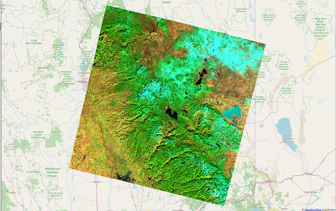
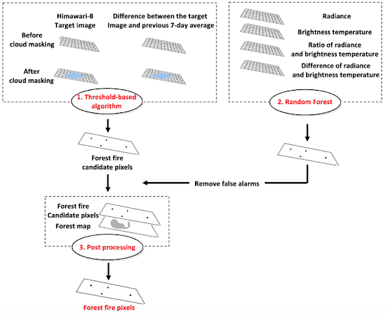
Startups and the emerging market for data science in forestry

Image
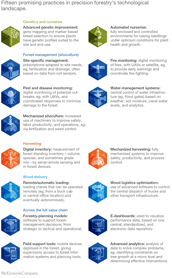
  Today, we’ll wrap up our look at how data science, machine learning and AI are transforming the forestry sector by exploring the market and startups in the field.   Forest products like timber, pulp, herbs and others contribute at least half a trillion dollars to the global economy each year. Now, while the word “forest” typically conjures up an image of a place that’s remote, hard to access and undisturbed - the truth is that a lot of forest products come from agro-forests. These are forests that are planted, harvested and maintained similar to crop fields - and thus, have similar issues to those seen in the agricultural sector. However, while there’s been a lot of interest in the agricultural sector on using data science, machine learning and artificial intelligence to solve problems, the forestry sector has been slower to catch on. But that’s been changing in the last couple of years - with Scandinavian countries and Canada leading the way. And the major developments have been in

Changing forests, Changing climate and Changing economies

  One of the fascinating aspects of working with data in clean technology is how variable the data are over space and time. So, as scientists trying to understand how different systems interact with each other, it usually means that we’re building several models that work together so that both the spatial and temporal aspects are accounted for.     And that’s especially true in the forestry sector. Forests are incredibly important ecosystems - untouched forests in the Amazon, Indonesia, the Congo Basin and other areas sequester carbon, provide habitat for species that cannot be found elsewhere and have been found to be important controllers of weather patterns locally and regionally. Additionally, second growth forests and agro-forests supply timber, medicines and other products that contribute close to $583 billion dollars every year to the global economy.   Further, as countries around the globe work on combating climate change, REDD+ payments or payments to developing countries for

When AI and Machine Learning come to the forests

  A big thank you to everyone who joined us last weekend for a lively and interesting discussion on data engineering and how to build prototypes that access satellite imagery using Google Earth Engine and Python.   It’s always fun to talk about satellites, imagery and how to get things to work in many different clean technology sectors - agriculture, water, energy, climate and disaster management among them.     Today, let’s talk about one sector that doesn’t get as much attention - forestry.   If you heard the the words forests and satellite imagery in one sentence, what comes to your mind? Deforestation? Reforestation? Wildfires? All three?   Managing our forests sustainably is key to protecting the environment in so many different ways - forests have a huge impact on climate, on ecosystem services and on the livelihoods of communities that rely on them. However, the challenge is that most forests are hard to access and data is often difficult to verify on the ground.     But that’s

When Satellite Data Improves - What Happens in Clean Technology?

  In June this year,   we had a lively discussion and online workshop on remote sensing data   and how monitoring processes occurring on the Earth was why the Landsat satellite program was launched in the 1970s - a program that’s still running today.     But here’s an interesting question that came up in our conversation - since water, agriculture, energy and other clean tech sectors have been using remote sensing data for such a long time - what is so different now?     To answer that question, let’s first talk about how satellite data is used in clean technology. The sectors where satellite data, and data science in general, are widely used both commercially and in research and development are agriculture, energy, water, climate and disaster management.   So, what are the different uses of satellite data in each of these sectors?   Let’s take agriculture first.   Researchers and scientists have been using satellite data since the 1970s in the agricultural sector. The first product fr

Reopening National Parks During the Pandemic - When Remote Sensing Can Help

Image
  It was great to meet so many folks at our live workshop session on Sunday - there were a lot of questions and we had fun in our hands-on problem - working through identifying the Camp Fire and estimating the damage it caused from remote sensing data.   If you missed it and are curious about remote sensing, you can still sign up for the online course and other courses   here . All the material that we cover in the live workshop, including our hands-on problem, is available in the course.   So today, let’s take a look at some of the latest research on building models from remote sensing data and see how these models can help us navigate the impacts from reopening high-value tourist destinations in the pandemic.   With all the data available from remote sensing hardware, one of biggest questions facing scientists and engineers working in the clean tech sector is - which data source is the most effective in solving the problem? In some cases, the answer jumps out right away - for example

When Remote Sensing Satellites Were First Launched....

  Did you know that the first photographs of the Earth’s surface were taken during the early Apollo missions as practice for mapping the Moon?     These early photographs provided the stimulus for launching the Landsat satellites in the 1970s - a program that provided the first civilian uses of satellite data - and is still going strong today. In today’s world of commercial satellites ringing the Earth, it seems almost quaint to remember that one of the arguments used most often against the Landsat program was that high-altitude aircraft could do the job just as well.   In fact, the story of how the Landsat program was created and the battles to get it off the ground is fascinating!   Back in the 1960s and 1970s, scientists were familiar with data from weather satellites and the kinds of questions they could answer. But what else could be seen from space? And how useful was it?   So, when the first Landsat satellite was launched on 23rd July 1972, the biggest questions were about the t

Launching on Sunday June 14th: Introduction to Remote Sensing - Online Course and Live Workshop

  Fun fact - did you know that some of the first non-military applications of  remote sensing  were in  clean technology  ? The Landsat program was started in the 1970s and the data were first used to map land cover, identify crops and other natural resources. Today, of course, we have satellites, drones and UAVs to give us data for many different applications - the question is how do we work with that data? In honor of World Environment Day , we will be hosting a live, hands-on workshop and online course on remote sensing data. If you've ever been curious about what remote sensing is, how the data are acquired and accessed and how to get started analyzing the data, come and join us on   Sunday, June 14th at  11am-12.30pm  Pacific Time. All our workshops use practical problems to understand the concepts - and in this workshop we'll be estimating the impact of wildfires using publicly available data for Camp Fire - the deadliest and most destructive fire that burned in Californi

Wildfires and the limitations of data science

  Let's get back to talking about wildfires! This is the second of our two post series on wildfires, data science and what we can do about them.   In the first post, we talked about satellite data and how it is used to track wildfires - especially large ones like we see in the Amazon this year. The wildfires burning in the Amazon have slipped off the front page of most newspapers, but they're still burning. And let's not forget the opposite end of the globe where wildfires in Indonesia are also burning out of control! The interesting aspect about wildfires and natural disasters in general is that most of the attention and resources are focused on dealing with them as they are happening and figuring out what resources are needed and what changes are needed after it's all over.  So, we see a lot of effort focused on satellite imagery, understanding wildfire extents after they have started, building apps and websites for people to access resources and tools during and afte

Wildfire monitoring from satellite data

Image
  We had a great time hosting our   "Getting started with Data Science for clean technology professionals" webinar  - a big thank you to everyone who registered and asked all those interesting questions!  If you're interested in getting the recording, it's now available for download on our website. And now, back to our regular posts on how data science is used in different clean tech fields! There's been a lot of news about the wildfires in the Amazon and the consequences for the planet, so let's talk about wildfire detection and how it's done. Wildfires, and in particular the Amazon fires, are detected using data from a wide range of satellites - NASA's array, the EU's Copernicus, Brazil's Terra satellites, Japan's Himawari-8, and CubeSats among others. But what exactly do these satellites see and how can you identify a wildfire from the data? Typically, satellites carry multi-spectral cameras or sensors on board. As the satellite passes o

Snippets: Monitoring crop diseases, infrastructure health and wildlife

  "If you can't measure it, can you fix it?"   One of the greatest challenges faced by almost everyone working in a clean technology field - water, agriculture, energy, climate, forestry, wildlife, soils, corporate sustainability, smart cities - is the challenge of monitoring. At its essence,this is the challenge of   what needs to be measured, how often and how accurately can it be done . Traditional methods of monitoring have involved sensors (of different levels of accuracy) placed in specific locations and the data removed and processed off-site by engineers and field analysts at specific time intervals. This is a time-consuming process, with data that isn't as frequent or as spatially dense or with as many parameters as decision makers and scientists would like - but, until recently that's been the best that we've had. The advent of smartphones, high-frequency and high resolution satellite data and the whole Internet of Things (IoT) is changing this parad

Nature’s Supply And Demand Problem

  “Supply and demand” is a phrase that’s more commonly associated with economics and business than with the environment. And yet, when we think about it – Nature provides several services that we take for granted… until they aren’t there anymore. Clean air for example – natural systems have filtered and purified air around cities and homes for many years, until the output from our cities becomes too much for the natural system and then we start noticing the smog and pollution. Or flood control – mangroves in the coastal areas of the tropics provide buffers against storm surges and flooding from hurricanes, until they are cut down for development and then we are faced with multi-million dollar damages from a storm.   Several ecologists and economists have worked together to try and figure out how best to quantify or price the services that natural systems provide, often called ecosystem services. But what happens as the environment changes, the climate warms and several ecosystems are t